The June 5, 2012 transit of Venus, the small dot to the right of centre, was captured by a Johnson Space Center photographer in Rocket Park. Courtesy: NASA
This hemispheric view of Venus, as revealed by more than a decade of radar investigations culminating in the 1990-1994 Magellan mission, is centered on the North Pole. NASA's Magellan spacecraft imaged more than 98 per cent of Venus.
A combination picture shows the planet Venus as it transits across the face of the sun as seen from the Greenwich Observatory on June 8, 2004 in London. The rare astronomical event last occurred in 1882, while the next transit is due in 2012. Getty Images
This photo of Venus was taken by the Galileo spacecraft.
In the early evening hours of the Space Shuttle Atlantis' first day in space for the four-day STS-30 mission, the Magellan spacecraft is released into space to begin its long journey to the planet Venus for an extensive radar mapping mission.
NASA's Mariner 2 was the world's first successful interplanetary spacecraft. Launched August 27, 1962, on an Atlas-Agena rocket, Mariner 2 passed within about 34,000 kilometers (21,000 miles) of Venus.
This archival image shows engineers at NASA's Jet Propulsion Laboratory looking at data related to the Venus flyby of Mariner 2 on Dec. 14, 1962. This was the first successful flyby of another planet.
Earth observation captured by crew members onboard Atlantis, Orbiter Vehicle (OV) 104, shows the sunset over the Earth as well as the planet Venus near the center of the frame.
Artist conception of surface of Venus. Courtesy NASA / Rick Guidice
This radar image from NASA's Magellan spacecraft is of a half crater located in the rift between Rhea and Theia Montes in Beta Regio on Venus and has been cut by many fractures or faults since it was formed by the impact of a large asteroid.
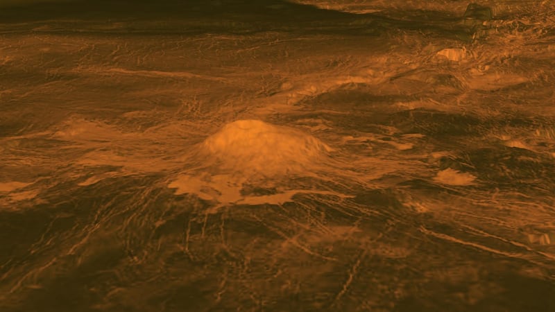
This figure shows the volcanic peak Idunn Mons in the Imdr Regio area of Venus. The topographic backbone (brown color) was derived from data obtained by NASA's Magellan spacecraft and the overlay was derived from data from ESA's Venus Express Spacecraft.
This radar mosaic from NASA's Magellan spacecraft shows a 600 kilometres segment of the longest channel discovered on Venus in 1990.
This is an updated montage of planetary images taken by spacecraft managed by NASA's Jet Propulsion Laboratory in Pasadena, CA. Included are (from top to bottom) images of Mercury, Venus, Earth (and Moon), Mars, Jupiter, Saturn, Uranus and Neptune.
This chart compares the first Earth-size planets found around a sun-like star to planets in our own solar system, Earth and Venus. NASA's Kepler mission discovered the newfound planets, called Kepler-20e and Kepler-20f.
The June 5, 2012 transit of Venus, the small dot to the right of centre, was captured by a Johnson Space Center photographer in Rocket Park. Courtesy: NASA
This hemispheric view of Venus, as revealed by more than a decade of radar investigations culminating in the 1990-1994 Magellan mission, is centered on the North Pole. NASA's Magellan spacecraft imaged more than 98 per cent of Venus.
A combination picture shows the planet Venus as it transits across the face of the sun as seen from the Greenwich Observatory on June 8, 2004 in London. The rare astronomical event last occurred in 1882, while the next transit is due in 2012. Getty Images
This photo of Venus was taken by the Galileo spacecraft.
In the early evening hours of the Space Shuttle Atlantis' first day in space for the four-day STS-30 mission, the Magellan spacecraft is released into space to begin its long journey to the planet Venus for an extensive radar mapping mission.
NASA's Mariner 2 was the world's first successful interplanetary spacecraft. Launched August 27, 1962, on an Atlas-Agena rocket, Mariner 2 passed within about 34,000 kilometers (21,000 miles) of Venus.
This archival image shows engineers at NASA's Jet Propulsion Laboratory looking at data related to the Venus flyby of Mariner 2 on Dec. 14, 1962. This was the first successful flyby of another planet.
Earth observation captured by crew members onboard Atlantis, Orbiter Vehicle (OV) 104, shows the sunset over the Earth as well as the planet Venus near the center of the frame.
Artist conception of surface of Venus. Courtesy NASA / Rick Guidice
This radar image from NASA's Magellan spacecraft is of a half crater located in the rift between Rhea and Theia Montes in Beta Regio on Venus and has been cut by many fractures or faults since it was formed by the impact of a large asteroid.
This figure shows the volcanic peak Idunn Mons in the Imdr Regio area of Venus. The topographic backbone (brown color) was derived from data obtained by NASA's Magellan spacecraft and the overlay was derived from data from ESA's Venus Express Spacecraft.
This radar mosaic from NASA's Magellan spacecraft shows a 600 kilometres segment of the longest channel discovered on Venus in 1990.
This is an updated montage of planetary images taken by spacecraft managed by NASA's Jet Propulsion Laboratory in Pasadena, CA. Included are (from top to bottom) images of Mercury, Venus, Earth (and Moon), Mars, Jupiter, Saturn, Uranus and Neptune.
This chart compares the first Earth-size planets found around a sun-like star to planets in our own solar system, Earth and Venus. NASA's Kepler mission discovered the newfound planets, called Kepler-20e and Kepler-20f.
The June 5, 2012 transit of Venus, the small dot to the right of centre, was captured by a Johnson Space Center photographer in Rocket Park. Courtesy: NASA